
 Department of Conservation and Recreation
Conserve. Protect. Enjoy.
Department of Conservation and Recreation


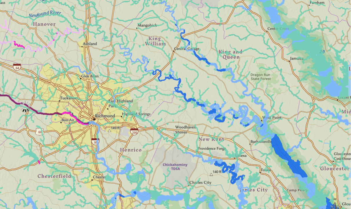
A screenshot of the mussel richness map. The dark blue areas show high potential richness for freshwater mussels. The dark magenta areas show high potential mussel richness as well, including at least one rare species.
The Virginia Natural Heritage Program has developed a mussel richness map to identify hotspots for native freshwater mussels, which serve a critical function in filtering water, within the Chesapeake Bay region. The map highlights areas where mussel restoration, land conservation and agricultural best management practices could be targeted, to support biodiversity and improve water quality. Click here to view the map (select the “Potential Freshwater Mussel Richness” layer): https://vanhde.org/content/map. We spoke with Joe Weber, chief of biodiversity information and conservation tools, who is leading the project.
Why is mussel biodiversity important?
With some 300 species, North America has the highest diversity of freshwater mussels in the world, but population and diversity declines caused by habitat alteration, pollution and invasive species have made them the most imperiled group of animals. Sixty-six percent of mussel species are at risk. Mussels perform important ecosystem services; they are filter feeders that help purify water for humans and wildlife. Healthy mussel populations are indicators of healthy and resilient aquatic systems.
Why is a map needed and what does it show?
The Scientific and Technical Advisory Committee of the Chesapeake Bay Program called for a comprehensive regional plan for mussel restoration and conservation and requested that we map “forested buffers that prioritize freshwater mussel outcomes.” In addition to modeling buffers, I pitched the idea of modeling the habitats of all mussel species and stacking them to estimate mussel richness in the Virginia Chesapeake Bay Watershed.
We produced a map of predicted total mussel richness that shows how many mussel species’ habitats may be found in various rivers and streams. The Virginia Natural Heritage Program has long used habitat models to aid in conservation of 179 rare plant and animal species, which include all threatened and endangered species and 40 globally rare species without government protections.
How will the map be used to guide restoration efforts?
The mussel richness map will help pinpoint where to focus additional mussel surveys and reintroduction efforts. The map will show where riparian buffers (trees, shrubs or other vegetation along a stream or waterway) and implementing other agricultural best management practices could be most impactful in improving the water quality that is so important for healthy mussel populations. Existing forests that are important for the quality of water associated with high mussel diversity may be targeted for conservation.
Will the map continue to be updated?
Yes. Natural Heritage zoologists are currently in the field surveying rivers and streams for mussels to validate the findings of the map and acquire more data to better understand mussel distributions and diversity. The map shows the 19 mussel species that occur in the Chesapeake Bay watershed of Virginia, but we are seeking funding to expand this project statewide — and perhaps even beyond.
Categories
Conservation | Natural Heritage
