Department of Conservation and Recreation Department of Conservation and Recreation
Conserve. Protect. Enjoy.
DCR Logo
Mobile Menu
Search DCR Site
Facebook Twitter YouTube Instagram LinkedIn
About DCR
 
State Parks
 
Natural
Heritage
Soil and Water
Conservation
Recreation
Planning
Dam Safety and
Floodplains
Land
Conservation
  • Dam Safety and Floodplains
  • Grants and Funding
    • Dam Safety, Flood Prevention and Protection Assistance Fund
    • Community Flood Preparedness Fund Grants and Loans
    • Resilient Virginia Revolving Loan Fund
  • Dam Safety
    • Dam Safety Guidance Documents
    • Dam Safety Contacts
    • Dam Classification
    • Dam Safety Regulations (PDF)
    • Dam Safety Education
      • Dams 101
      • Dam Failures
      • Dam Safety Awareness Day
      • ASDSO Dam Owner Academy
      • Hurricane Season
      • Dam Safety Outreach
    • Dam Safety, Flood Prevention and Protection Assistance Fund
      • 2024 Grant Awards List (PDF)
      • 2023 Grant Awards List (PDF)
      • 2022 Grant Awards List (PDF)
    • Dam Safety Inventory System (DSIS)
    • Probable Maximum Precipitation Study and PMP Evaluation Tool
    • Probable Maximum Precipitation Study Background
    • Temporal Distribution Analysis and Calculations Worksheet
    • Vegetation, Erosion
    • Rodent Control
    • Forms
  • Floodplains
    • Va. Floodplain Management Program
    • Floodplain Regulations and Ordinances
    • Virginia Flood Risk Information System
    • Natural Functions of Floodplains
    • Community Rating System
    • Floodplain Management Resources
    • Flood Awareness in Virginia
      • Flood Awareness Week
      • Outreach Resources
    • Floodplain Contacts
    • Flood Resilience Funding
      • Community Flood Preparedness Fund Grants and Loans
        • 2024 Grant Awards List
      • Resilient Virginia Revolving Loan Fund
  • Flood Resilience Planning
    • Virginia Flood Protection Master Plan
      • Get Involved
    • Virginia Coastal Resilience Master Plan
      • Coastal Resilience Master Planning Framework
      • Coastal Resilience Master Plan, Phase 1
      • Coastal Resilience Master Plan, Phase 2
      • Coastal Resilience Web Explorer
      • Web Explorer User Portal
    • Outreach and Engagement
    • Calendar, Training and Events
    • Flood Resilience Advisory Committee
    • Annual Flood Preparedness Coordination Meeting
    • Open Data Portal
    • Resources and Reports
  • Calendar, Training and Events
  • Open GIS Data Hub
Home » Dam Safety And Floodplains » PMP tool

Probable Maximum Precipitation Study and Evaluation Tool

Map depicting regions PMP study covers

Probable Maximum Precipitation Study for Virginia and Associated PMP Evaluation Tool and Database (November 2015)

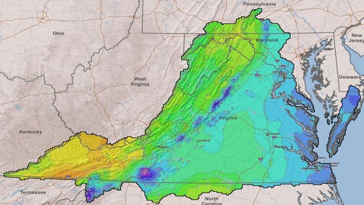
This study provides gridded Probable Maximum Precipitation (PMP) values (2.5 square mile grids) for any drainage basin within Virginia, including regions adjacent to the state that drain into basins within Virginia. These values replace those provided in Hydrometeorological Reports (HMRs) including, but not limited to, 40, 51, 52 and 56 (1965, 1978, 1982 and 1986 respectively). Results of this analysis reflect the most current practices used for defining PMP, including comprehensive storm analyses procedures, extensive use of geographical information systems (GIS), explicit quantification of orographic effects, updated maximum dew point climatologies for storm maximization and transposition, and an updated understanding of the weather and climate throughout the state.

The Virginia Soil and Water Conservation Board adopted the Probable Maximum Precipitation Study for Virginia and the Associated PMP Evaluation Tool and Database on Dec. 9, 2015. Here are the Impounding Structure Regulations (4VAC50-20) that made the Probable Maximum Precipitation values effective on March 23, 2016 (Section 4VAC50-20-50 was amended). The board’s Guidance Document on New Probable Maximum Precipitation Implementation became effective on that date and was revised on March 29, 2018..

Deliverables from the PMP study are available for download below.

  • PMP Final Report and Appendices
    • Executive Summary
    • Final Report
    • Appendices A-E, G-K (67Mb)
    • Appendix F (76Mb)
  • Pre-run PMPs
    • Virginia PMPs Pre-run For 900+ High and Significant Hazard Dams (Zipped - 218Mb). Note: This file may take several hours to unzip because of the volume of data.
  • PMP Evaluation GIS Tool and Implementation and Certification Guidance
    • PMP Tool (Zipped - 67Mb) Tool works in ArcMap and ArcPro platforms.
    • PMP Tool Description and Usage
    • PMP Evaluation Tool Training Document (February 2016)
    • Virginia PMP 2015 Watershed Calculation Spreadsheet (revised September 2016)
    • Guidance Document on New Probable Maximum Precipitation (PMP) Implementation
    • Certification Form: Review of New Probable Maximum Precipitation Values (effective March 23, 2016) using the PMP Evaluation Tool

Disclaimer

All deliverables for the Virginia Probable Maximum Precipitation Study are being provided herein with the expressed understanding that the Virginia Department of Conservation and Recreation (DCR) and the Commonwealth of Virginia are releasing these products at the user's own risk. This study is based on the best information, science and techniques available, however no warranty, expressed or implied, is made regarding the accuracy, adequacy, completeness or reliability of the data provided. These data are provided on an "as is" basis. Neither DCR nor the contributors of said data to the DCR shall be held liable for any use or application of the data provided whatsoever, whether or not that use is improper or incorrect, and assume no responsibility for the use or application of the data or information derived from interpretation of the data. In no event shall DCR or its collaborators be liable for any direct, indirect or incidental damages arising from the use or application of these data. This disclaimer of liability applies to any damages or injury, including but not limited to those caused by any failure of performance including failures resulting in personal injury or property damage, error, omission, defect, delay in operation or transmission, computer virus, alteration, use, application, analysis or interpretation of data. It is the owner's engineer and/or other end users who are expected to take all steps necessary to ensure proper use and understanding of these products and that all information is being properly interpreted and applied.

Users should check back routinely for updates as data will be added and changed periodically resulting in some data becoming out-of-date. It is recommended that the user not let a significant period of time elapse between obtaining and using the data.

See also Probable Maximum Precipitation Study Background

Virginia Department of Conservation and Recreation
600 East Main Street, 24th floor | Richmond, VA 23219-2094 | 804-786-6124
Please send website comments to web@dcr.virginia.gov
Address general inquiries to pcmo@dcr.virginia.gov
Copyright © 2025, All Rights Reserved
Last Modified: Wednesday, 28 May 2025, 02:23:28 PM
eVA Transparency Reports View the Virginia Department of Conservation and Recreation's expenditures.
Contact Us | Media Center | Privacy Policy | ADA Notice | FOIA | Jobs | Code of Ethics (PDF)
DCR Organizational Chart (PDF) | Strategic Plan (PDF) | Executive Progress Report (PDF) | Public Safety & Law Enforcement