Department of Conservation and Recreation Department of Conservation and Recreation
Conserve. Protect. Enjoy.
DCR Logo
Mobile Menu
Search DCR Site
Facebook Twitter YouTube Instagram LinkedIn
About DCR
 
State Parks
 
Natural
Heritage
Soil and Water
Conservation
Recreation
Planning
Dam Safety and
Floodplains
Land
Conservation
  • Natural Heritage
  • About Natural Heritage
    • Overview, Mission
    • Natural Heritage Inventory
    • Community Ecology Program
    • Healthy Waters Program
    • Information Management
    • Environmental Review
    • Natural Area Protection
    • Stewardship
    • Staff
    • Internships
  • Natural Area Preserves
    • Public Access Guide (PDF)
    • Special Events and Hunting
    • Natural Area Research
  • Rare Species and Natural Communities
    • Rare Species and Natural Community Search
    • Rare Species and Natural Community Lists
    • Natural Communities of Virginia
    • Locality Summary Maps
    • Rare Butterfly and Dragonfly Atlas
  • Information Services
    • Info Services Order Form
    • Locality Assistance Program
    • NH Data Explorer
    • Species and Community Search
    • ConservationVision and Green Infrastructure
    • Telecommunication Towers (PDF)
    • Conservation Lands Database
    • Wetlands Catalog
    • Species Habitat Modeling
  • Pollinator Smart Solar Site Portal
    • Comprehensive Manual (PDF)
    • Scorecard Templates
    • Virginia Native Plant Finder
  • Native Plants
    • Benefits
    • Natives vs. Aliens
    • Buying and Growing
    • Virginia's Physiographic Provinces
    • Native Plant Finder
    • Flora of Virginia
    • Policy 151 - Plantings on Department Lands
  • Invasive Plants
    • Invasive Plant List
    • What You Can Do
    • Factsheets
    • Invasive Species Working Group
  • Invertebrates
    • Monarch butterflies
  • Caves/Karst
    • Cave Board
    • Cave and Karst Trail
  • Publications
    • Flora of Virginia
    • Peer Reviewed Papers
    • Enews
    • Brochures and Factsheets
    • NH Plan
Home » Natural Heritage » Natural Heritage Data Explorer

Department of Conservation and Recreation's
Virginia Natural Heritage Data Explorer


Natural Heritage Data Explorer map

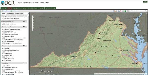
Natural Heritage Data Explorer (NHDE) is an ArcGIS Server based interactive mapping application that anyone can use to map the conservation status and conservation values of lands. To subscribers (organizations), NHDE provides additional sensitive data pertaining to Natural Heritage Resources for web-based, site specific environmental review. The interactive map displays a variety of data layers, including county boundaries, roads, streams, watershed boundaries, conservation lands, various conservation priority layers and statewide topographic and aerial photography.

Please note, many data layers and functionalities on NHDE are publicly accessible and do not require a subscription. However, to view certain sensitive data layers and functionalities a subscription is required with login credentials. More information about Non-subscriber and Subscriber access to NHDE can be found below.

NHDE Non-subscriber Access

For those interested in learning more about the publicly accessible data layers and functionality available on NHDE without a subscription, please watch this video tutorial series which also provides an overview of the Natural Heritage Program. Please email nhdesupport@dcr.virginia.gov if you have any questions about NHDE after watching the videos.

NHDE Subscriber Access

Virtual NHDE subscriber training:
  • There will be a virtual NHDE training session for current and potential subscribers offered Wednesday, July 23, 2025 from 1-3pm

Organizations (agencies, companies, and non-profits) can subscribe to NHDE obtaining login credentials to gain tiered access to additional sensitive data and functionality pertaining to Natural Heritage Resources for site specific environmental review. In addition, NHDE subscribers can:

  • view, select and identify specific features on the map pertaining to Natural Heritage Resources, such as rare species, conservation sites, karst resources and predictive models of species distribution
  • submit project boundaries to DCR directly through NHDE and receive a detailed report on potential impacts to Natural Heritage Resources. Project boundaries of any size can be digitized on screen, or uploaded via shapefile.
  • provide and administer site access to other individuals within their organization

For more information about the tiered access levels of a subscription, please visit the "Access and Permissions" section of the NHDE User Guide. NHDE subscription pricing related to for-profit organizations is outlined on the Information Services Order Form under the Subscription Services section.

As a condition of registration, all subscribers are required to sign a License agreement or Memorandum of Agreement agreeing to applicable Terms and Conditions. All users of this website, whether subscription administrators and/or subscription members, are required to adhere to these Terms and Conditions.

New subscribing organizations are also required to participate in an introductory training session for NHDE. This training, provided virtually every two months, greatly expedites the efficient use of the site. See the notice at the top of this page for information about upcoming training sessions.

If you are interested in attending training, please send a request with contact information to nhdetraining@dcr.virginia.gov.

Virginia Department of Conservation and Recreation
600 East Main Street, 24th floor | Richmond, VA 23219-2094 | 804-786-6124
Please send website comments to web@dcr.virginia.gov
Address general inquiries to pcmo@dcr.virginia.gov
Copyright © 2025, All Rights Reserved
Last Modified: Wednesday, 28 May 2025, 02:39:21 PM
eVA Transparency Reports View the Virginia Department of Conservation and Recreation's expenditures.
Contact Us | Media Center | Privacy Policy | ADA Notice | FOIA | Jobs | Code of Ethics (PDF)
DCR Organizational Chart (PDF) | Strategic Plan (PDF) | Executive Progress Report (PDF) | Public Safety & Law Enforcement