
 Department of Conservation and Recreation
Conserve. Protect. Enjoy.
Department of Conservation and Recreation


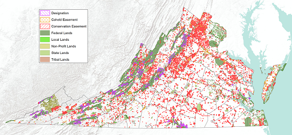
DCR began digitally mapping the boundaries for agency owned and managed State Parks and State Natural Area Preserves in 1998. In August of 1999, the Department of Technology Planning designated DCR as the lead agency in developing the Commonwealth's state-wide Conservation Lands Database. Since this mandate, our database has grown to include state, federal, private, and locally managed lands and conservation easements.
DCR is also responsible for tracking Virginia's progress toward several important land conservation goals. Initially DCR began tracking progress toward the Chesapeake Bay 2000 Agreement land conservation goal of protecting 20% of the Chesapeake Bay Watershed by 2010. DCR was also responsible for tracking the progress of Former Governor Tim Kaine's 4-year, 400,000 acre Land Conservation Goal and is now in the progress of tracking a third 400,000 acre Land Conservation Initiative set out by Governor McAuliffe This land conservation information is gathered from many sources on a monthly basis and managed within a geospatial and tabular Managed Areas Database. DCR includes these lands in the Conservation Lands Database as soon as an accurate boundary can be delineated.
GIS boundaries for conservation lands are acquired in digital form when available, from state and federal land management agencies and localities. DCR State Park and State Natural Area Preserve boundaries were created in-house from best available sources, including digital surveys. Boundaries for many locally owned and managed conservation lands were created by DCR staff using a variety of maps and other sources. The methods of digital boundary creation, and the resulting accuracy, are dependent on the mapping sources available at the time a boundary is created. Several attribute fields are included in the download data that note the original format, accuracy, and origin of individual boundaries.
In cases of boundary overlap between different land management agencies, we did not attempt to edgematch or otherwise correct conflicts. These inconsistencies are a result of the differences in data development methods and the accuracy of source materials. Please contact the original data creator with questions concerning boundary accuracy, placement, and overlap. DCR, as the central repository for Virginia Conservation Lands data, is consistently working to resolve such issues in mapping boundaries based on information and additional data from various sources. DCR continually seeks GIS data to update and improve this database. To contribute, contact, the Conservation Lands GIS Planner.
DCR is continually reviewing and updating the Conservation Lands Database. Updated data are provided on a quarterly basis in March, June, September and December. The current quarterly update date is posted next to each dataset in the download data section on the DCR website for the Conservation Lands Database.
Metadata and ArcView Shapefile format data are provided for download in compressed ZIP files. Shapefiles are in decimal degrees (unprojected), and North American Datum 1983. All of the shapefile attribute tables are consistent allowing for easy merging in GIS. Great effort has been taken to create a database that is user friendly and may be applied to many types of analyses. The MATYPE field may be used to classify the conservation lands into different groups.
GIS boundaries are not intended for legal uses and no warranty, expressed or implied, is made by the Virginia Department of Conservation and Recreation (DCR) as to the accuracy of this data. The act of distribution shall not constitute any such warranty, and no responsibility is assumed by the DCR or in the use of these data. Re-distribution of these data for profit is prohibited.
Of the estimated total land area of Virginia, 25.27 million acres, over 4.28 million acres or 16.96% is "currently protected". June, 2023
| GROUP | EASEMENTS | FEE-SIMPLE | TOTAL ACRES CONSERVED | PERCENTAGE OF TOTAL |
|---|---|---|---|---|
| Federal | 14,692.77 | 2,339,253.35 | 2,353,946.12 | 54.92% |
| State | 986,712.51 | 450,121.80 | 1,436,834.31 | 33.52% |
| Local | 48,599.35 | 110,463.06 | 159,062.42 | 3.71% |
| Non-Profit | 234,067.59 | 101,815.69 | 335,883.28 | 7.84% |
| Tribal | 0.00 | 504.00 | 504.00 | 0.01% |
| TOTALS: | 1,284,072.21 | 3,002,157.91 | 4,286,230.12 | 100.00% |
Please use this link to access updated information about land protection goals related to the Chesapeake Bay Watershed Agreement.
DCR's Office of Land Conservation has more information on land conservation and protection options available for citizens and organizations.
