
 Department of Conservation and Recreation
Conserve. Protect. Enjoy.
Department of Conservation and Recreation


The Virginia National Watershed Boundary Dataset (VaNWBD) was completed in 2006 and has been updated several times since then, most recently in 2019. What follows explains what the VaNWBD is and how it differs from previous and coexisting hydrologic unit systems.
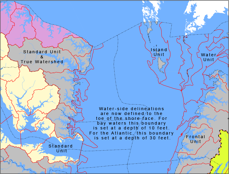
The terms watershed and hydrologic unit are used throughout DCR’s website. Do both terms refer to the same thing? Almost. A true watershed is an area of land and water defined by a boundary such that all surface drainage within the boundary converges to a single point. This point of convergence is usually the exit point or outlet, where the collected waters leave the watershed. There are, however, watersheds out of which no water flows.
In contrast, hydrologic units are drainage areas that are delineated so as to nest into a multi-level hierarchical drainage system. Aside from the surface waters that are collected within the boundary of a hydrologic unit, it may also accept water from one or more points outside of the unit’s boundary. The tidal portion of the James River is a good example. It can be a hydrologic unit but not a watershed because water enters this unit from both the non-tidal (Piedmont) James River at Richmond and the Appomattox River at Hopewell. Additionally, hydrologic units may include associated surface areas whose drainages do not connect, thus resulting in multiple outlet points. This is usually the case with coastal frontage units such as those containing multiple outlets to the Chesapeake Bay or Atlantic Ocean.
Click the map below to view the main types of hydrologic units in the VaNWBD.
According to the classic definitions, all watersheds are hydrologic units but not all hydrologic units are watersheds. In the development of hydrologic units, watersheds are inherently preferred: They are the perfect hydrologic unit.
You may notice that there is no mention of size in the above definitions of watersheds and hydrologic units. How big or small may they be? Watersheds may be as big or as small as they need to be to correctly be referred to as a watershed. A hierarchical hydrologic unit system, on the other hand, has levels that are based on the size of the area within the boundaries of the units.
A hierarchical hydrologic unit system for the US started in the 1970s and has been modified several times since. Our HU origins page describes the original form and subsequent changes to those units in Virginia prior to the development of the national Watershed Boundary Dataset.
In 2001 the NRCS, USGS, EPA and other federal agencies teamed with the Subcommittee on Spatial Water Data — part of the Advisory Committee on Water Information (ACWI) — and the Federal Geographic Data Committee (FGDC) to develop a new hydrologic unit delineation standard. With state input, the new Federal Standards for Delineation of Hydrologic Unit Boundaries was created. The new standards establish a new set of seamless 5th and 6th level hydrologic units for the entire U.S. The digital products resulting from the delineation and capture of these new units is the Watershed Boundary Dataset (WBD). The WBD became the country’s official hydrologic unit system at that time, although WBD standards continue to evolve.
As part of the WBD development process in Virginia, 6th level units were delineated by DCR so as to preserve as much of the intent of the 1995 Virginia Hydrologic Unit boundaries as possible in order to make the transition between the two systems less complicated.
There are several major differences between the new standards and those used to develop the pre-NWBD Virginia Hydrologic Unit system:
The Atlantic Ocean — out to the 3 nautical mile territorial limit — is now part of the hydrologic unit system and has been partitioned into 5th and 6th level hydrologic units.
Click the map below to view WBD Subbasin Units that cover Virginia. They replace the previous Cataloging Units.
| LEVEL | WBD DIGITS | OLD DIGITS | WBD NAME | OLD NAME | UNIT SIZE |
|---|---|---|---|---|---|
| 1 | 2 | 2 | Region | Region | Avg. 177,560 sq. miles |
| 2 | 4 | 4 | Subregion | Sub-Region | Avg. 16,800 sq. miles |
| 3 | 6 | 6 | Basin | Accounting Unit | Avg. 10,596 sq. miles |
| 4 | 8 | 8 | Subbasin | Cataloging Unit | Avg. 703 sq. miles |
| 5 | 10 | 11 | Watershed | Range: 40,000 to 250,000 acres | |
| 6 | 12 | 14 | Subwatershed | Range: 10,000 to 40,000 acres |
The new unit name reference “Watershed” above may refer to hydrologic units that are not actually watersheds as correctly defined at the top of this page. Therefore, to avoid the unfortunate confusion these references create, DCR refers to the various orders of hydrologic units by their level instead of their name.
To uniquely identify hydrologic units in Virginia without requiring the use of 10 or 12 digits, DCR developed a new four-character internal coding scheme for the 5th and 6th level units. This four-character code replaces the three-character code of the previous 14-digit system. The first two characters of the new code are based on the major stream name in the basin, or portion of the basin, where the unit is located (see Table 4). The two digits that follow these codes are a sequential numbering scheme based on the drainage flow (headwaters to mouth).
This four-character unit identifier (VAHU6) is not part of the WBD standard. Additional non-standard variables also were added to the new Virginia hydrologic unit system (percent water, tidal influence, revised name). To differentiate the standard WBD of Virginia with the form that includes non-standard variables, the customized non-standard form is referred to as the Virginia National Watershed Boundary Dataset (VaNWBD).
The VaNWBD has been updated a number of times since its initial release in July 2006 due to correction needs, WBD adjustments in adjoining states, continued standards changes and state boundary adjustments. The current form is referred to as version 6 (VaNWBDv6).
Table 4 displays the internal coding scheme for 5th and 6th level units of the VaNWBDv6.
| 5th LEVEL UNITS (VAHU5) | 6th LEVEL UNITS (VAHU6) | DRAINAGE |
|---|---|---|
| PL-A - PL-U | PL01-PL74 | Potomac River, Lower |
| PU-A - PU-F | PU01-PU22 | Potomac River, Upper |
| PS-A - PS-T | PS01-PS87 | Potomac River-Shenandoah River |
| CB-A - CB-O | CB01-CB47 | Chesapeake Bay/Chesapeake Bay Coastal |
| AO-A - AO-H | AO01-AO26 | Atlantic Ocean Coastal |
| RA-A - RA-R | RA01-RA74 | Rappahannock River |
| YO-A - YO-S | YO01-YO69 | York River |
| JL-A - JL-L | JL01-JL59 | James River, Lower (Tidal) |
| JM-A - JM-U | JM01-JM86 | James River, Middle (Piedmont) |
| JR-A - JR-E | JR01-JR22 | James River- Rivanna River |
| JU-A - JU-T | JU01-JU86 | James River, Upper (Mountain) |
| JA-A - JA-J | JA01-JA45 | James River- Appomattox River |
| CM-A - CM-H | CM01-CM32 | Chowan River-Meherrin River |
| CU-A - CU-R | CU01-CU70 | Chowan River, Upper |
| CL-A - CL-C | CL01-CL05 | Chowan River, Lower |
| AS-A - AS-D | AS01-AS20 | Albemarle Sound |
| RU-A - RU-V | RU01-RU94 | Roanoke River, Upper |
| RD-A - RD-S | RD01-RD77 | Roanoke River- Dan River |
| RL-A - RL-G | RL01-RL24 | Roanoke River, Lower |
| YA-A - YA-B | YA01-YA07 | Yadkin River-Ararat River |
| NE-A - NE-Z | NE01-NE90 | New River |
| TH-A - TH-L | TH01-TH46 | Tennessee-Holston River |
| TC-A - TC-H | TC01-TC35 | Tennessee-Clinch River |
| TP-A - TP-D | TP01-TP19 | Tennessee-Powell River |
| BS-A - BS-H | BS01-BS35 | Big Sandy River |
VaNWBDv6 consists of 1,251 6th level units, an increase of four over the 1,247 6th level units found in VaNWBDv4. The additional units occur from an update to the Virginia-West Virginia boundary.
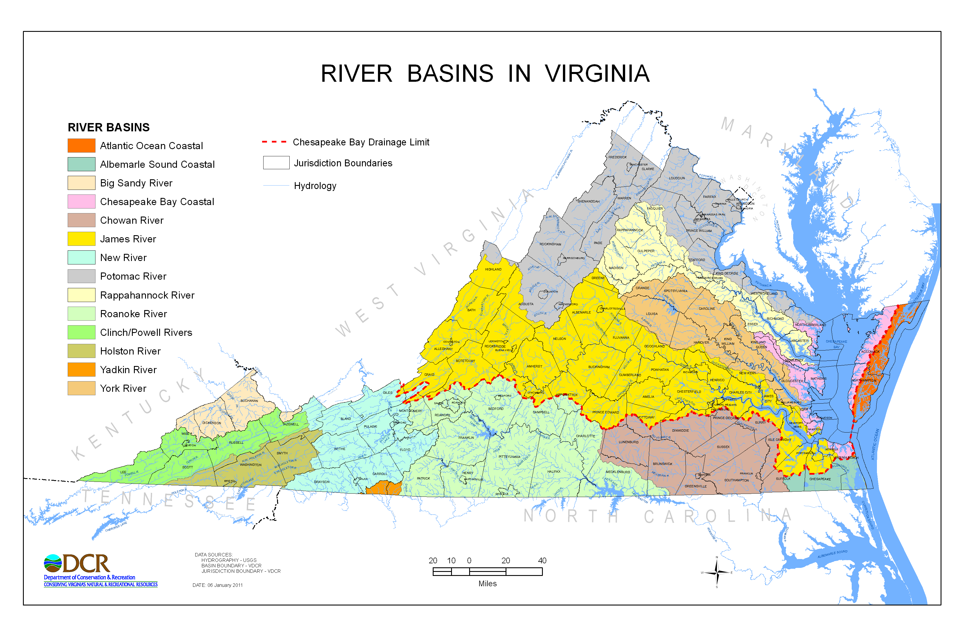
Although 3rd level units of the WBD are called "Basins," these units are not necessarily the equivalent of river basins as described in many state programs. For instance, DCR frequently divides the commonwealth into 14 River Basins for program usage as follows: Potomac River, Rappahannock River, York River, James River, Atlantic Ocean Coastal, Chesapeake Bay Coastal, Chowan River, Albemarle Sound Coastal, Roanoke River, Yadkin River, New River, Clinch-Powell Rivers, Holston River and Big Sandy River. Except for offshore ocean claims, all of Virginia is accounted for in these basins.
Click the map below to view a map of the described River Basins in detail.
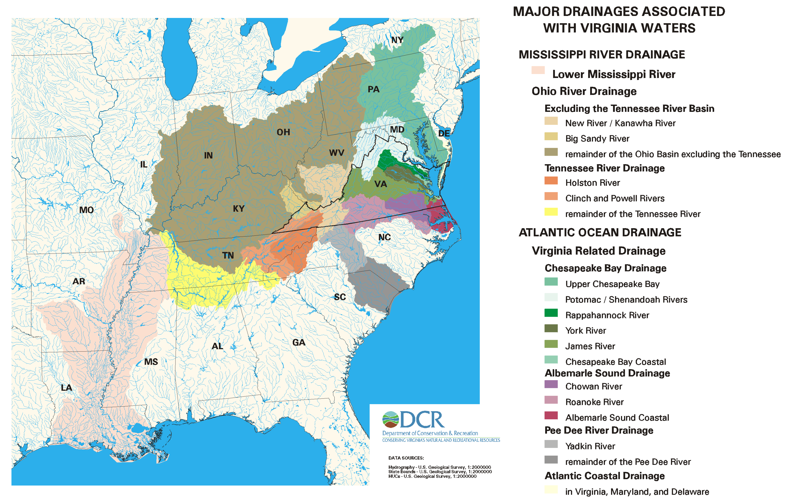
Click the map below for a map depicting major drainages - some outside the state - that are associated with Virginia's waters.
Where do the Virginia River Basins fit in the hydrologic unit system? The short answer is that they don’t. They are not a level of that system. Most of them are 3rd level units, but others are just a collection of contiguous 4th level units. The York River Basin, for example, is a collection of three 4th level units (02080105, 02080106 and 02080107) found in the Lower Chesapeake 3rd level unit (020801). These three 4th level units not only form the York River Basin but also comprise, based on our previous definitions, the York River Watershed.
Why do we use an unofficial collection of hydrologic units such as these River Basins when previously defined levels of hydrologic units are the standard? DCR, like most Virginia state agencies, is primarily concerned with activities and occurrences within the state. State agencies in any other state have similar focus. For program purposes and the program needs of other agencies in the commonwealth, having the Rappahannock River Watershed combined with the York River Watershed, as well as with small coastal drainage basins to the Chesapeake Bay, the Chesapeake Bay itself and Atlantic Ocean drainage, is unacceptable. We basically created an unofficial system that suits our purposes.>
Unfortunately, when a hydrologic unit system is unofficial, it is subject to alteration at will. What suits DCR’s needs one year may not the next. As well, other state agencies might have or might encounter different needs. Within DCR, the River Basin system has been modified over the years in a manner that is not always consistent between programs. Likewise the system used by state agencies has varied. Therefore, as opposed to the River Basin system defined above, you will also find versions where the Upper Potomac and Shenandoah rivers are in a separate Basin from the Lower Potomac Basin, or where the Chowan River Basin is combined with the Albemarle Sound Coastal Basin, etc.>
Although there is no River Basin hydrologic unit standard, river basins are composed of contiguous hydrologic units that do meet hydrologic unit development standards. For instance, combining the Potomac River Watershed to the James River Watershed would be incorrect unless you also combined them all to the other surface waters that flow into the Chesapeake Bay that lie between the Potomac and the James.
Version 6 of the Virginia NWBD is as an ESRI file geodatabase or a shapefile for those wanting to use this layer in their geographic information systems. VaNWBDv6 is a July 2019 update to the comparable layer VaNWBDv5 of 2019.
The WBD for the United States is available from the USGS WBD website.
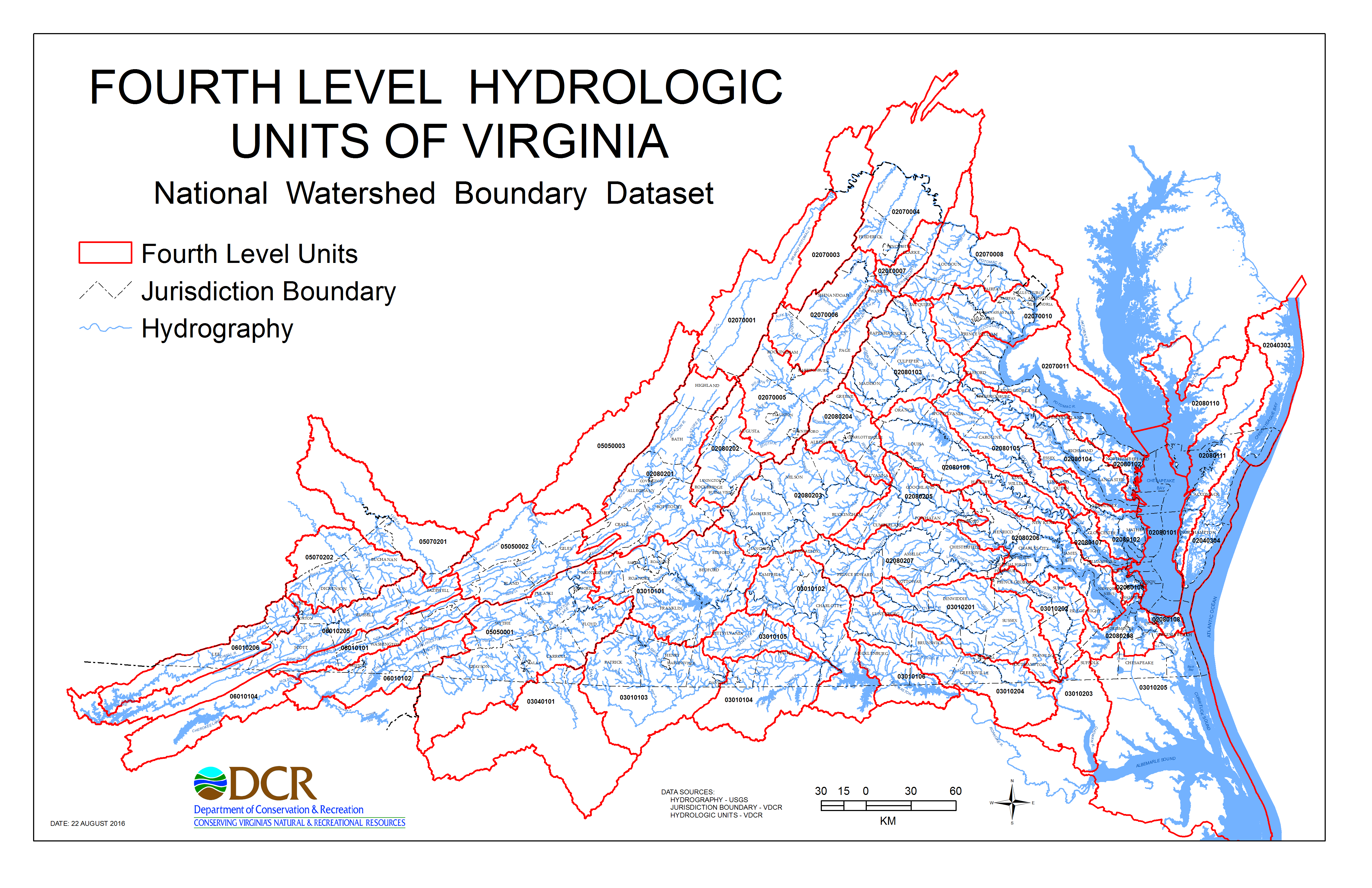
View an interactive map of Virginia's hydrologic units of the 4th-6th units of VaNWBDv6.
