Department of Conservation and Recreation
Conserve. Protect. Enjoy.
Department of Conservation and Recreation


The Virginia National Watershed Boundary Dataset (VaNWBD) was completed in 2006 and has been updated several times since then. What follows describes earlier versions of the hydrologic unit systems covering Virginia and how they differ from the current VaNWBD.
Initial federal hydrologic unit standards were set in the 1970s. These standards divided the U.S. into the units listed in Table 1.
| LEVEL | DIGITS | ENGLISH NAME | UNIT SIZE |
|---|---|---|---|
| 1 | 2 | Region | Avg. 177,560 sq. miles |
| 2 | 4 | Sub-Region | Avg. 16,800 sq. miles |
| 3 | 6 | Accounting Unit | Avg. 10,596 sq. miles |
| 4 | 8 | Cataloging Unit | Avg. 703 sq. miles |
A numeric string can identify any hydrologic unit, at any of these levels. For instance, a Sub-Region is identifiable by a four-digit code (e.g., 0208). The more digits required to identify a hydrologic unit, the smaller that unit is in area. This is a nested hierarchical system: You can tell which Region and Subregion a 3rd level unit lies within by the first two and first four digits of the six-digit 3rd level unit code, respectively.
Because the old Cataloging Units averaged 703 square miles in size nationally, they were too large an area to evaluate as a single entity in regard to water quality conditions at the state level. Evaluating such an expanse would result in generalizations that could completely mask problem areas. Therefore, in Virginia, we delineated more detailed sets of hydrologic units for this purpose in the past.
DCR’s soil and water conservation program staff and the U.S. Department of Agriculture Natural Resources Conservation Service (USDA-NRCS) delineated detailed 6th level hydrologic units for Virginia in 1990 and again in 1995 following the issuance of new hydrologic unit delineation standards in 1992. The 1995 delineation resulted in the creation of a hydrologic unit system containing 494 individual units in Virginia, each averaging about 54,000 acres. A unique 14-digit string was created to identify each unit, thus these units are often referred to as the 14-digit hydrologic units. In Virginia a three-character code (e.g., A32) was also created for each unit for identification purposes, particularly for use on maps.
This 14-digit system was the official 6th level set of hydrologic units for Virginia from 1995 to July of 2006. It was widely used as a geographical identifier for water related data and issues. DCR and the NRCS also produced maps, an atlas, and digital files of the boundaries, codes and descriptions of this system to promote its use.
A selective merging of the 6th level units was done in 1996 to produce a 5th level hydrologic unit system, also referred to as the 11-digit hydrologic unit system. While both the 5th and 6th level systems were developed using established hydrologic unit standards, only the 5th level set was completed in all the states surrounding Virginia. Through the efforts of the NRCS, the 5th level units were made seamless between the states.
Although it was a goal of the hydrologic unit development standards of the time to not affect delineation of the existing 4th level units during 6th level development (except to more precisely recapture them), a few significant modifications and redefinition of established 2nd through 4th level units were made in cooperation with the NRCS. These changes, which affected multiple states, were requested to fix the more glaring problems created by imposing 5th and 6th level units from the new standards onto noncompliant larger units developed in the 1970’s.
This modification had to eventually occur if any hydrologic unit system was to be delineated to new higher levels correctly. The long history of use of the 1st through 4th level unit coding, however, meant that many past unit recordings would no longer correlate to the new hydrologic unit system. It is important to note where these unit designation changes occurred, as they persist through all subsequent hydrologic unit systems, even while the distribution of old hydrologic unit system maps with now incorrect codes continues:
Table 2 lists the English references for all 1st through 4th order units in Virginia and indicates in red which of these units have had their references altered as a result of the above change.
| 1st Level | 2nd Level | 3rd Level | 4th Level |
|---|---|---|---|
| 02 - Mid-Atlantic | 0204 - Delaware - Mid-Atlantic Coastal | 020403 - Mid-Atlantic Coastal | 02040303 - Chincoteague 02040304 - Eastern Lower Delmarva |
| 0207 - Potomac | 020700 - Potomac | 02070001 - South Branch 02070003 – Cacapon-Town 02070004 - Conococheague-Opequon 02070005 - South Fork Shenandoah 02070006 - North Fork Shenandoah 02070007 - Shenandoah 02070008 - Middle Potomac-Catoctin 02070010 - Middle Potomac-Anacostia-Occoquan 02070011 - Lower Potomac |
|
| 0208 - Lower Chesapeake | 020801 - Lower Chesapeake | 02080101 - Lower Chesapeake 02080102 - Great Wicomico-Piankatank 02080103 - Rapidan-Upper Rappahannock 02080104 - Lower Rappahannock 02080105 - Mattaponi 02080106 - Pamunkey 02080107 - York 02080108 - Lynnhaven-Poquoson 02080110 - Tangier 02080111 - Pocomoke-Western Lower Delmarva |
|
| 020802 - James | 02080201 - Upper James 02080202 - Maury 02080203 - Middle James-Buffalo 02080204 - Rivanna 02080205 - Middle James-Willis 02080206 - Lower James 02080207 - Appomattox 02080208 - Hampton Roads |
||
| 03 - South Atlantic-Gulf | 0301 - Chowan-Roanoke | 030101 - Roanoke | 03010101 - Upper Roanoke 03010102 - Middle Roanoke 03010103 - Upper Dan 03010104 - Lower Dan 03010105 - Banister 03010106 - Roanoke Rapid |
| 030102 - Albemarle-Chowan | 03010201 - Nottoway 03010202 - Blackwater 03010203 - Chowan 03010204 - Meherrin 03010205 - Albemarle |
||
| 0304 - Pee Dee | 030401 - Upper Pee Dee | 03040101 - Upper Yadkin | |
| 05 - Ohio | 0505 - Kanawha | 050500 - Kanawha | 05050001 - Upper New 05050002 - Middle New |
| 0507 - Big Sandy | 050702 - Big Sandy | 05070201 - Tug 05070202 - Upper Levisa |
|
| 06 - Tennessee | 0601 - Upper Tennessee | 060101 - French Broad-Holston | 06010101 - North Fork Holston 06010102 - South Fork Holston 06010104 - Holston |
| 060102 – Upper Tennessee | 06010205 - Upper Clinch 06010206 - Powell |
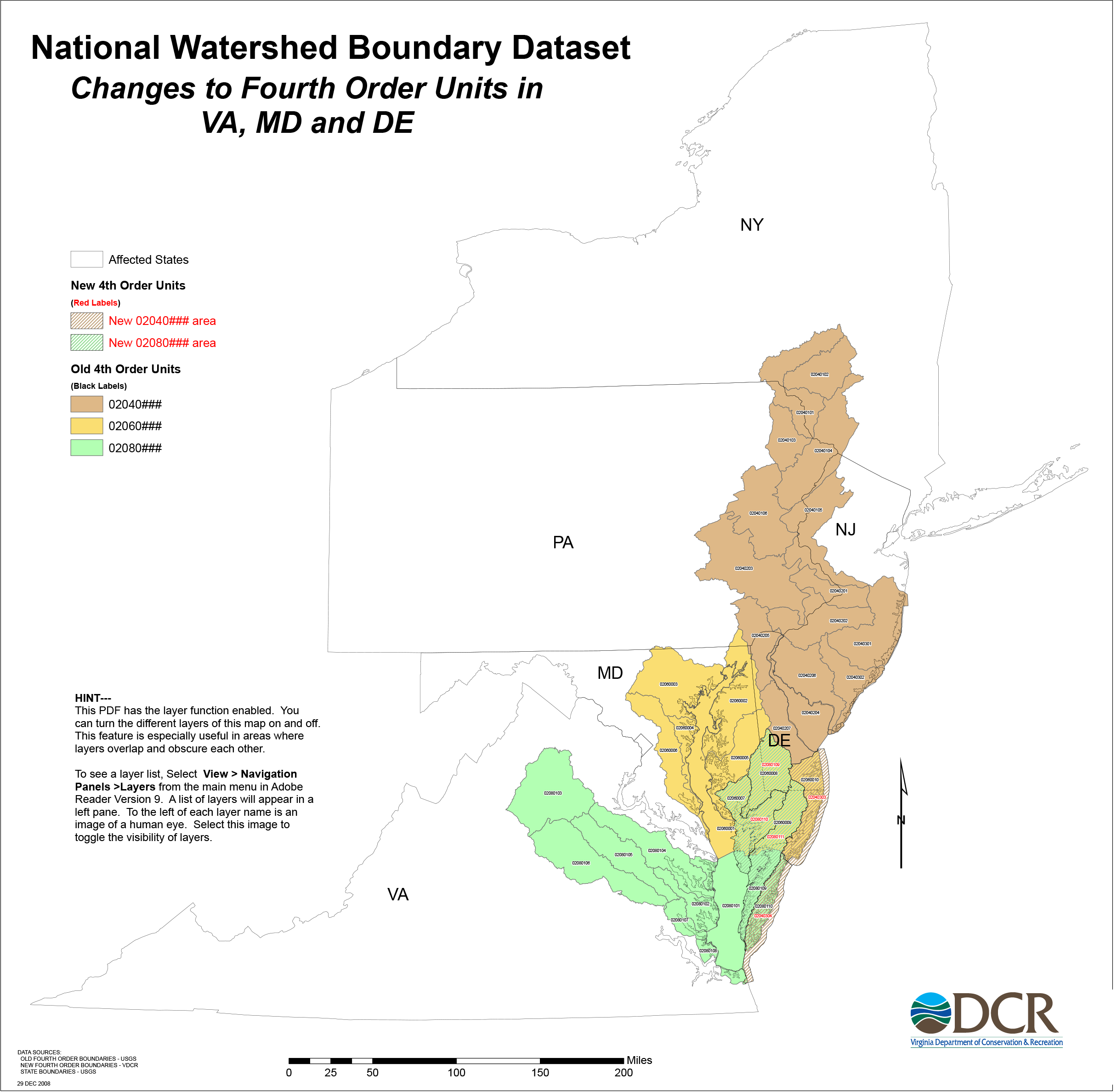
Click the image below to view a larger map as a PDF. Then download the PDF.
This PDF has the layer function enabled in Adobe Acrobat. You can turn the different layers of this map on and off. This feature is useful in areas where layers overlap and obscure each other.
To see a layer list, select the Layers icon from the left window pane in Adobe Acrobat Reader. A list of layers will appear in the pane. To the left of each layer's name is an image of a human eye. Select this image to toggle the visibility of the layers.