Department of Conservation and Recreation Department of Conservation and Recreation
Conserve. Protect. Enjoy.
DCR Logo
Mobile Menu
Search DCR Site
Facebook Twitter YouTube Instagram LinkedIn
About DCR
 
State Parks
 
Natural
Heritage
Soil and Water
Conservation
Recreation
Planning
Dam Safety and
Floodplains
Land
Conservation
  • Dam Safety and Floodplains
  • Grants and Funding
    • Dam Safety, Flood Prevention and Protection Assistance Fund
    • Community Flood Preparedness Fund Grants and Loans
    • Resilient Virginia Revolving Loan Fund
  • Dam Safety
    • Dam Safety Guidance Documents
    • Dam Safety Contacts
    • Dam Classification
    • Dam Safety Regulations (PDF)
    • Dam Safety Education
      • Dams 101
      • Dam Failures
      • Dam Safety Awareness Day
      • ASDSO Dam Owner Academy
      • Hurricane Season
      • Dam Safety Outreach
    • Dam Safety, Flood Prevention and Protection Assistance Fund
      • 2024 Grant Awards List (PDF)
      • 2023 Grant Awards List (PDF)
      • 2022 Grant Awards List (PDF)
    • Dam Safety Inventory System (DSIS)
    • Probable Maximum Precipitation Study and PMP Evaluation Tool
    • Probable Maximum Precipitation Study Background
    • Temporal Distribution Analysis and Calculations Worksheet
    • Vegetation, Erosion
    • Rodent Control
    • Forms
  • Floodplains
    • Va. Floodplain Management Program
    • Floodplain Regulations and Ordinances
    • Virginia Flood Risk Information System
    • Natural Functions of Floodplains
    • Community Rating System
    • Floodplain Management Resources
    • Flood Awareness in Virginia
      • Flood Awareness Week
      • Outreach Resources
    • Floodplain Contacts
    • Flood Resilience Funding
      • Community Flood Preparedness Fund Grants and Loans
        • 2024 Grant Awards List
      • Resilient Virginia Revolving Loan Fund
  • Flood Resilience Planning
    • Virginia Flood Protection Master Plan
      • Get Involved
    • Virginia Coastal Resilience Master Plan
      • Coastal Resilience Master Planning Framework
      • Coastal Resilience Master Plan, Phase 1
      • Coastal Resilience Master Plan, Phase 2
      • Coastal Resilience Web Explorer
      • Web Explorer User Portal
    • Outreach and Engagement
    • Calendar, Training and Events
    • Flood Resilience Advisory Committee
    • Annual Flood Preparedness Coordination Meeting
    • Open Data Portal
    • Resources and Reports
  • Calendar, Training and Events
  • Open GIS Data Hub
Home » Dam Safety And Floodplains » Natural functions of floodplains

Natural functions of floodplains

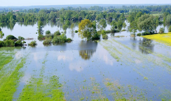
Floodplains serve a crucial natural function in managing floods by providing storage areas for excess water during times of high flow. Acting as natural sponges, floodplains absorb and temporarily hold floodwaters, reducing the speed and intensity of flooding downstream.

Additionally, well-managed floodplains facilitate the gradual release of stored water, replenishing groundwater supplies and supporting the health of surrounding ecosystems. By absorbing and redirecting floodwaters, floodplains help mitigate flood damage, protect communities, and maintain the balance of natural water systems.

Significant research has revealed the many beneficial roles natural floodplains play.

Floodplains support local economies and quality of life by:

  • Improving property values for areas near natural areas and out of the floodplain due to natural aesthetics and access to recreational opportunities
  • Reducing flood damage and cleanup costs
  • Ensuring faster recovery from flood events
  • Supporting ecosystem services
  • Enabling more attractive and resilient waterfront districts
  • Providing potential access for recreation
  • Having the potential for multiple funding sources for community projects that combine hazard mitigation with open space or historic preservation, recreation, quality of life and other shared goals
Flooded field - source - https://www.earth.com/news/flooding-help-river-ecosystems/
Source: https://www.earth.com/news/flooding-help-river-ecosystems/

Water Resource Benefits

  • Natural flood, erosion, and sediment control
    • Provide areas of floodwater storage
    • Reduce flood velocities, giving us more time to react to floods
    • Reduce flood peaks
    • Reduce sedimentation
  • Soil and Water
    • Filter nutrients and impurities from runoff
    • Process organic wastes
    • Help moderate temperature fluctuations
    • Potential reduction in dredging costs
    • Lower water treatment costs
  • Groundwater recharge
    • Promote infiltration and recharge of the aquifer
    • Slowly release water to reduce infrequency and duration of low surface flows
  • Fish and wildlife habitat
    • Provide breeding and feeding grounds
    • Create and enhance waterfowl habitat
    • Protect habitat for rare and endangered species
    • Support industries that rely on the biological resources
Lynnhaven River in Virginia Beach
Source: City of Virginia Beach Public Works - Lynnhaven River

Protected Areas

Coastal Barrier Resource System (CBRS) areas are mapped by the U.S. Fish and Wildlife Service and include CBRS Units, Otherwise Protected Areas (OPAs) and Resource Protection Areas (RPAs).

CBRS Units - Relatively undeveloped lands, generally privately held, intended to follow geomorphic, development or cultural features.

OPAs - Generally consist of lands held by a qualified organization. The areas are primarily for wildlife refuge, sanctuary, recreational or natural resource conservation purposes.

RPAs - Corridors of environmentally sensitive lands that lie alongside or near the shorelines of streams, rivers and other waterways.

Coverage under the National Flood Insurance Program is not available for new or substantially improved structures in CBRS areas. Historically, these areas were shown on Flood Insurance Rate Maps, but CBRS areas were removed from these maps in February 2019. These areas are available on VFRIS. To view current boundaries and the official CBRS mapper, visit the U.S. Fish and Wildlife Service Coastal Barrier Resources Act page.

Endangered Species Act

The Endangered Species Act establishes protections for fish, wildlife, and plants that are listed as threatened or endangered; provides for adding species to and removing them from the list of threatened and endangered species, and for preparing and implementing plans for their recovery; provides for interagency cooperation to avoid take of listed species and for issuing permits for otherwise prohibited activities; provides for cooperation with States, including authorization of financial assistance; and implements the provisions of the Convention on International Trade in Endangered Species of Wild Flora and Fauna (CITES).

Endangered Species Act of 1973

Additional Resources

  • A Flood of Benefits: Using Green Infrastructure to Reduce Flood Risks (The Nature Conservancy)
  • Benefits of Natural Floodplains (FEMA)
  • Natural and Beneficial Floodplain Functions: Floodplain Management - More than Loss Reduction (ASFPM)
  • ConserveVirginia Mapper
  • Flood Risk and Endangered Species Habitat (FRESH) Mapping Tool


Contact Floodplain Management at FloodplainMgmt@dcr.virginia.gov

Virginia Department of Conservation and Recreation
600 East Main Street, 24th floor | Richmond, VA 23219-2094 | 804-786-6124
Please send website comments to web@dcr.virginia.gov
Address general inquiries to pcmo@dcr.virginia.gov
Copyright © 2025, All Rights Reserved
Last Modified: Wednesday, 28 May 2025, 02:23:28 PM
eVA Transparency Reports View the Virginia Department of Conservation and Recreation's expenditures.
Contact Us | Media Center | Privacy Policy | ADA Notice | FOIA | Jobs | Code of Ethics (PDF)
DCR Organizational Chart (PDF) | Strategic Plan (PDF) | Executive Progress Report (PDF) | Public Safety & Law Enforcement