Department of Conservation and Recreation Department of Conservation and Recreation
Conserve. Protect. Enjoy.
DCR Logo
Mobile Menu
Search DCR Site
Facebook Twitter YouTube Instagram LinkedIn
About DCR
 
State Parks
 
Natural
Heritage
Soil and Water
Conservation
Recreation
Planning
Dam Safety and
Floodplains
Land
Conservation
  • Natural Heritage
  • About Natural Heritage
    • Overview, Mission
    • Natural Heritage Inventory
    • Community Ecology Program
    • Healthy Waters Program
    • Information Management
    • Environmental Review
    • Natural Area Protection
    • Stewardship
    • Staff
    • Internships
  • Natural Area Preserves
    • Public Access Guide (PDF)
    • Special Events and Hunting
    • Natural Area Research
  • Rare Species and Natural Communities
    • Rare Species and Natural Community Search
    • Rare Species and Natural Community Lists
    • Natural Communities of Virginia
    • Locality Summary Maps
    • Rare Butterfly and Dragonfly Atlas
  • Information Services
    • Info Services Order Form
    • Locality Assistance Program
    • NH Data Explorer
    • Species and Community Search
    • ConservationVision and Green Infrastructure
    • Telecommunication Towers (PDF)
    • Conservation Lands Database
    • Wetlands Catalog
    • Species Habitat Modeling
  • Pollinator Smart Solar Site Portal
    • Comprehensive Manual (PDF)
    • Scorecard Templates
    • Virginia Native Plant Finder
  • Native Plants
    • Benefits
    • Natives vs. Aliens
    • Buying and Growing
    • Virginia's Physiographic Provinces
    • Native Plant Finder
    • Flora of Virginia
    • Policy 151 - Plantings on Department Lands
  • Invasive Plants
    • Invasive Plant List
    • What You Can Do
    • Factsheets
    • Invasive Species Working Group
  • Invertebrates
    • Monarch butterflies
  • Caves/Karst
    • Cave Board
    • Cave and Karst Trail
  • Publications
    • Flora of Virginia
    • Peer Reviewed Papers
    • Enews
    • Brochures and Factsheets
    • NH Plan
Home » Natural Heritage » Virginia ConservationVision Agricultural Model
ConservationVision | Agriculture | Cultural Resources | Development Vulnerability | Forest Conservation | Natural Landscapes | Potential Rare Species Richness | Nature-based Recreation Access | Watershed Impact

Agricultural Model

Model last updated August 2015.

map of VA ConservationVision agricultural model

Abstract

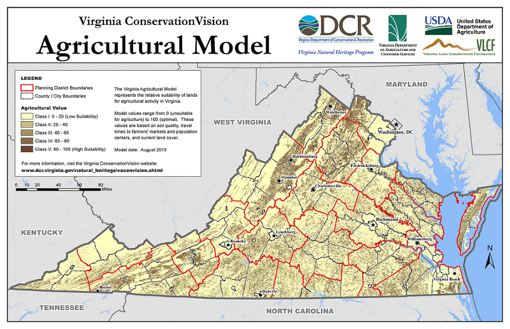
The Virginia Agricultural Model was developed to quantify the relative suitability of lands for agricultural activity across the state. It is presented as a raster data set and associated maps, in which the relative agricultural value of lands ranges from 0 (unsuitable) to 100 (optimal). This provides some of the information needed for prioritizing lands that may be placed under conservation easements in the interest of sustaining agricultural values and uses.

In this model, agricultural value is assessed primarily based on inherent soil suitability, but also accounts for current land cover as well as travel time between agricultural producers and consumers. Among others, staff at the Natural Resources Conservation Service (NRCS) and the Virginia Department of Agriculture and Consumer Services (VDACS) were consulted to ensure a robust model. The Virginia Agricultural Model is one of several in a suite of conservation planning and prioritization models developed by the Virginia Natural Heritage Program and partners, known collectively as Virginia ConservationVision.

Details

A technical report provides detailed information about the Virginia Agricultural Model. Included in the report are:
  • A general introduction to the model
  • A list of all input datasets used to develop the model
  • Detailed description of the methodology used to produce the model and its components
  • A series of maps providing visual representation of the relative agricultural value of lands across the state, as well as across each planning district
  • Discussion of the differences between the current and previous versions of the model, appropriate uses for the model, and model limitations.

Click here to access the technical report.

Online Mapping

The model is available for interactive viewing at ArcGIS Online and on the Virginia Natural Heritage Data Explorer.

Data Downloads

Raster data with metadata are available for download in ArcGIS file geodatabase format. The geodatabase contains the following four raster datasets, each with 30-m pixels:
  • Agricultural Model, 2015 edition
  • Soil Quality Score (model component quantifying inherent soil suitability for agriculture)
  • Foodshed Score (model component with values based on average travel times to farmers' markets, urban areas, and large metro areas)
  • Land Cover Score (model component quantifying the relative suitability of different land cover types for agricultural use or conversion)

In addition, an ArcGIS map package (MPK file) is available for download. Once you have downloaded and unzipped the file, use the "Extract Package" tool in ArcGIS to extract the MPK file to the folder of your choice. The map package contains vector data (polygons) representing the original soil map units obtained from the gSSURGO database. The polygons are attributed and symbolized with the Soil Quality Score, as well as three sub-scores from which that score is derived. This is a primary dataset from which the Agricultural Model was developed, and is likely to be useful in its own right.

Click here to register and download the data. High-resolution maps (PDF or PNG format) and alternative raster data formats are available on request.

More Information

For more information about the Agricultural Model, please contact Shiva.Torabian@dcr.virginia.gov, phone: 804-225-2820.

Virginia Department of Conservation and Recreation
600 East Main Street, 24th floor | Richmond, VA 23219-2094 | 804-786-6124
Please send website comments to web@dcr.virginia.gov
Address general inquiries to pcmo@dcr.virginia.gov
Copyright © 2025, All Rights Reserved
Last Modified: Wednesday, 28 May 2025, 02:39:20 PM
eVA Transparency Reports View the Virginia Department of Conservation and Recreation's expenditures.
Contact Us | Media Center | Privacy Policy | ADA Notice | FOIA | Jobs | Code of Ethics (PDF)
DCR Organizational Chart (PDF) | Strategic Plan (PDF) | Executive Progress Report (PDF) | Public Safety & Law Enforcement