Department of Conservation and Recreation Department of Conservation and Recreation
Conserve. Protect. Enjoy.
DCR Logo
Mobile Menu
Search DCR Site
Facebook Twitter YouTube Instagram LinkedIn
About DCR
 
State Parks
 
Natural
Heritage
Soil and Water
Conservation
Recreation
Planning
Dam Safety and
Floodplains
Land
Conservation
  • Natural Heritage
  • About Natural Heritage
    • Overview, Mission
    • Natural Heritage Inventory
    • Community Ecology Program
    • Healthy Waters Program
    • Information Management
    • Environmental Review
    • Natural Area Protection
    • Stewardship
    • Staff
    • Internships
  • Natural Area Preserves
    • Public Access Guide (PDF)
    • Special Events and Hunting
    • Natural Area Research
  • Rare Species and Natural Communities
    • Rare Species and Natural Community Search
    • Rare Species and Natural Community Lists
    • Natural Communities of Virginia
    • Locality Summary Maps
    • Rare Butterfly and Dragonfly Atlas
  • Information Services
    • Info Services Order Form
    • Locality Assistance Program
    • NH Data Explorer
    • Species and Community Search
    • ConservationVision and Green Infrastructure
    • Telecommunication Towers (PDF)
    • Conservation Lands Database
    • Wetlands Catalog
    • Species Habitat Modeling
  • Pollinator Smart Solar Site Portal
    • Comprehensive Manual (PDF)
    • Scorecard Templates
    • Virginia Native Plant Finder
  • Native Plants
    • Benefits
    • Natives vs. Aliens
    • Buying and Growing
    • Virginia's Physiographic Provinces
    • Native Plant Finder
    • Flora of Virginia
    • Policy 151 - Plantings on Department Lands
  • Invasive Plants
    • Invasive Plant List
    • What You Can Do
    • Factsheets
    • Invasive Species Working Group
  • Invertebrates
    • Monarch butterflies
  • Caves/Karst
    • Cave Board
    • Cave and Karst Trail
  • Publications
    • Flora of Virginia
    • Peer Reviewed Papers
    • Enews
    • Brochures and Factsheets
    • NH Plan
Home » Natural Heritage » Virginia ConservationVision Cultural Resource Preservation Index
ConservationVision | Agriculture | Cultural Resources | Development Vulnerability | Forest Conservation | Natural Landscapes | Potential Rare Species Richness | Nature-based Recreation Access | Watershed Impact

Cultural Resource Preservation Index

Cultural resource preservatin index map

Abstract

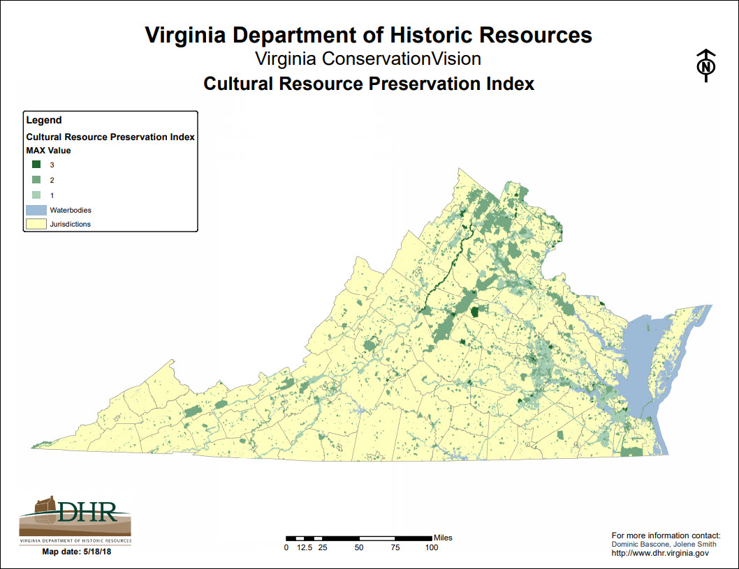
The Virginia Department of Historic Resources (http://www.dhr.virginia.gov/) developed the Cultural Resource Preservation Index as a replacement to the original Cultural Model. The index ranks cultural resources according to cultural interest and displays the likelihood of a given location to have conservation value when considering known and evaluated cultural heritage resources. Resources considered protected by a cultural based conservation easement or other means were excluded from this index (those protected features can be found in the VBHR Easements layer). For the purposes of obscuring sensitive boundaries, the Commonwealth of Virginia was divided into a hexagon grid (individual hexagons are ~250 acres in size). This process was done to protect sensitive resources. Not all resources included here are sensitive but the idea was to create a simple and easy to interpret dataset. Resources that have been surveyed in the inventory of the Department of Historic Resources (DHR) were ranked by levels of cultural interest, defined in the attribute field MAX_Preservation_Index as:

3 = Listed as National Historic Landmarks (Highest)

2 = Listed on, contributing to, or eligible for listing on the National Register of Historic Places/Virginia Landmarks Register

1 = Surveyed sites/properties without formal recommendations of eligibility for listing on the National Register of Historic Places but have potential for eligibility.

This dataset does not include sites/properties that remain unevaluated, nor does it include areas of the commonwealth that have not been surveyed for cultural resources.

Resources with rankings attached were joined to the hexagons and all attribute data was stripped away. The index value for each hex is equal to the highest value of cultural significance contained within it. For example, if three resources overlap within a hexagon with values of 2, 1, and 3 the value of the hexagon will be 3. The index value is not cumulative.

Application of the Cultural Resource Preservation Index

Some general categories of uses to which the cultural resource preservation index can be applied include:
  • Targeting- to identify targets for protection activities.
  • Prioritizing- to provide primary or additional justification for key conservation land purchases and other protection activities.
  • Land management- to guide property owners and public and private land managers in making land management decisions that enhance cultural values.
  • Public education- to inform the citizenry about the cultural value of their community, helping retain the unique sense of place associated with these communities.

Data Download

  • Cultural Resource Preservation Index and Virginia Board of Historic Resources held easements (ArcMap Layer File)

More Information

For more information about the Cultural Model, please contact Dominic Bascone at Dominic.Bascone@dhr.virginia.gov or 804-482-6101.

Page last updated 5/18.

Virginia Department of Conservation and Recreation
600 East Main Street, 24th floor | Richmond, VA 23219-2094 | 804-786-6124
Please send website comments to web@dcr.virginia.gov
Address general inquiries to pcmo@dcr.virginia.gov
Copyright © 2025, All Rights Reserved
Last Modified: Wednesday, 28 May 2025, 02:39:20 PM
eVA Transparency Reports View the Virginia Department of Conservation and Recreation's expenditures.
Contact Us | Media Center | Privacy Policy | ADA Notice | FOIA | Jobs | Code of Ethics (PDF)
DCR Organizational Chart (PDF) | Strategic Plan (PDF) | Executive Progress Report (PDF) | Public Safety & Law Enforcement