Department of Conservation and Recreation Department of Conservation and Recreation
Conserve. Protect. Enjoy.
DCR Logo
Mobile Menu
Search DCR Site
Facebook Twitter YouTube Instagram LinkedIn
About DCR
 
State Parks
 
Natural
Heritage
Soil and Water
Conservation
Recreation
Planning
Dam Safety and
Floodplains
Land
Conservation
  • Natural Heritage
  • About Natural Heritage
    • Overview, Mission
    • Natural Heritage Inventory
    • Community Ecology Program
    • Healthy Waters Program
    • Information Management
    • Environmental Review
    • Natural Area Protection
    • Stewardship
    • Staff
    • Internships
  • Natural Area Preserves
    • Public Access Guide (PDF)
    • Special Events and Hunting
    • Natural Area Research
  • Rare Species and Natural Communities
    • Rare Species and Natural Community Search
    • Rare Species and Natural Community Lists
    • Natural Communities of Virginia
    • Locality Summary Maps
    • Rare Butterfly and Dragonfly Atlas
  • Information Services
    • Info Services Order Form
    • Locality Assistance Program
    • NH Data Explorer
    • Species and Community Search
    • ConservationVision and Green Infrastructure
    • Telecommunication Towers (PDF)
    • Conservation Lands Database
    • Wetlands Catalog
    • Species Habitat Modeling
  • Pollinator Smart Solar Site Portal
    • Comprehensive Manual (PDF)
    • Scorecard Templates
    • Virginia Native Plant Finder
  • Native Plants
    • Benefits
    • Natives vs. Aliens
    • Buying and Growing
    • Virginia's Physiographic Provinces
    • Native Plant Finder
    • Flora of Virginia
    • Policy 151 - Plantings on Department Lands
  • Invasive Plants
    • Invasive Plant List
    • What You Can Do
    • Factsheets
    • Invasive Species Working Group
  • Invertebrates
    • Monarch butterflies
  • Caves/Karst
    • Cave Board
    • Cave and Karst Trail
  • Publications
    • Flora of Virginia
    • Peer Reviewed Papers
    • Enews
    • Brochures and Factsheets
    • NH Plan
Home » Natural Heritage » Virginia ConservationVision Nature-based Recreation Access Model 2021
ConservationVision | Agriculture | Cultural Resources | Development Vulnerability | Forest Conservation | Natural Landscapes | Potential Rare Species Richness | Nature-based Recreation Access | Watershed Impact

Nature-based Recreation Access Model (2021 version)

Model last updated June 2021.

land-based recreation needs map water-based recreation needs map

News

Data downloads and a technical report for the 2021 model are now available; see below.

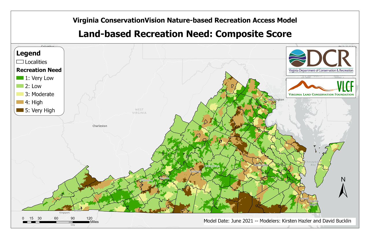
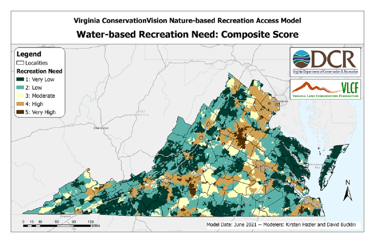
If you are willing to fill out a quick survey about your use of this and other Virginia ConservationVision models, please click here. This will also enable you to sign up for notifications about model updates.

Abstract

The purpose of the Nature-based Recreation Access Model is to quantify the availability of opportunities for nature-based recreation on Virginia's public lands and waters, and to identify areas where more opportunities are needed. We developed two sets of metrics to evaluate land- and water-based recreation needs. The land-based recreation metrics include:

  • Travel time to the nearest protected land with public access (PPA) offering at least 5 acres of available greenspace
  • The number of PPAs offering at least 100 acres of available greenspace, that can be reached within a 30-minute drive
  • The number of PPAs offering at least 600 acres of available greenspace, that can be reached within a 60-minute drive
  • Land-based recreation pressure, based on population size and the amount of available greenspace within service catchments and gaps delineated for PPAs with at least 25 acres of available greenspace
The water-based recreation metrics include:
  • Travel time to the nearest water access point
  • The number of water access points that can be reached within a 30-minute drive
  • The number of water-based activities (fishing, swimming, or boating) that can be reached within a 30-minute drive
  • Water-based recreation pressure, based on population size within service catchments and gaps delineated for water access points

Model metrics were scored, weighted, and combined to compute composite measures of land-based and water-based recreation need. The model is a contribution to the digital conservation planning atlas known as Virginia ConservationVision. It is intended to assist land planners prioritizing lands for conservation and recreation access, and is used by granting organizations such as the Virginia Land Conservation Foundation to help allocate funding for various conservation and recreation projects. It is also intended to be used in conjunction with ConserveVirginia, Virginia's official land conservation strategy.

Details

Details of the model methods and results are available in a technical report.

Additional model information materials include:

  • A slide deck giving an overview of the model
  • Frequently asked questions
  • A recording of an informational webinar held on April 27, 2021

Online Mapping

An interactive web map, including all recreation need scores, is available on ArcGIS Online. The composite score layers are also available on Natural Heritage Data Explorer in the "Conservation Planning" section.

Data Downloads

The following raster datasets (TIF format, 30-m resolution) are available for download:

  • Water-based Recreation Need
    • Composite Score
    • Proximity Score
    • Access Options Score
    • Activities Options Score
    • Pressure Score
  • Land-based Recreation Need
    • Composite Score
    • Proximity Score
    • Local Options Score
    • Regional Options Score
    • Pressure Score

If you are interested in intermediate data products not listed above, please contact Kirsten Hazler to inquire about availability.

Additional Resources

The Virginia Recreation Access Model is fundamentally a regional/statewide model. For more detailed, city-level analysis related to parks access, you may be interested in the "ParkScore" analysis provided by the Trust for Public Land. ParkScores are available for several cities in Virginia:

  • Arlington
  • Virginia Beach
  • Norfolk
  • Chesapeake
Analyses for other cities may be found by using the search box at the bottom of any of the above pages.

The Trust for Public Land also provides the ParkServe online mapping service to help park planners determine the best locations for adding new local parks. The goal is to strategically place parks to ensure that all city dwellers can walk to a public greenspace within 10 minutes.

Contact Information

For more information please contact Shiva.Torabian@dcr.virginia.gov, phone: 804-225-2820.

Page last updated 7/2021.

Virginia Department of Conservation and Recreation
600 East Main Street, 24th floor | Richmond, VA 23219-2094 | 804-786-6124
Please send website comments to web@dcr.virginia.gov
Address general inquiries to pcmo@dcr.virginia.gov
Copyright © 2025, All Rights Reserved
Last Modified: Wednesday, 28 May 2025, 02:39:20 PM
eVA Transparency Reports View the Virginia Department of Conservation and Recreation's expenditures.
Contact Us | Media Center | Privacy Policy | ADA Notice | FOIA | Jobs | Code of Ethics (PDF)
DCR Organizational Chart (PDF) | Strategic Plan (PDF) | Executive Progress Report (PDF) | Public Safety & Law Enforcement