Department of Conservation and Recreation Department of Conservation and Recreation
Conserve. Protect. Enjoy.
DCR Logo
Mobile Menu
Search DCR Site
Facebook Twitter YouTube Instagram LinkedIn
About DCR
 
State Parks
 
Natural
Heritage
Soil and Water
Conservation
Recreation
Planning
Dam Safety and
Floodplains
Land
Conservation
  • Natural Heritage
  • About Natural Heritage
    • Overview, Mission
    • Natural Heritage Inventory
    • Community Ecology Program
    • Healthy Waters Program
    • Information Management
    • Environmental Review
    • Natural Area Protection
    • Stewardship
    • Staff
    • Internships
  • Natural Area Preserves
    • Public Access Guide (PDF)
    • Special Events and Hunting
    • Natural Area Research
  • Rare Species and Natural Communities
    • Rare Species and Natural Community Search
    • Rare Species and Natural Community Lists
    • Natural Communities of Virginia
    • Locality Summary Maps
    • Rare Butterfly and Dragonfly Atlas
  • Information Services
    • Info Services Order Form
    • Locality Assistance Program
    • NH Data Explorer
    • Species and Community Search
    • ConservationVision and Green Infrastructure
    • Telecommunication Towers (PDF)
    • Conservation Lands Database
    • Wetlands Catalog
    • Species Habitat Modeling
  • Pollinator Smart Solar Site Portal
    • Comprehensive Manual (PDF)
    • Scorecard Templates
    • Virginia Native Plant Finder
  • Native Plants
    • Benefits
    • Natives vs. Aliens
    • Buying and Growing
    • Virginia's Physiographic Provinces
    • Native Plant Finder
    • Flora of Virginia
    • Policy 151 - Plantings on Department Lands
  • Invasive Plants
    • Invasive Plant List
    • What You Can Do
    • Factsheets
    • Invasive Species Working Group
  • Invertebrates
    • Monarch butterflies
  • Caves/Karst
    • Cave Board
    • Cave and Karst Trail
  • Publications
    • Flora of Virginia
    • Peer Reviewed Papers
    • Enews
    • Brochures and Factsheets
    • NH Plan
Home » Natural Heritage » Virginia ConservationVision Potential Rare Species Richness
ConservationVision | Agriculture | Cultural Resources | Development Vulnerability | Forest Conservation | Natural Landscapes | Potential Rare Species Richness | Nature-based Recreation Access | Watershed Impact

Potential Rare Species Richness

Model last updated May 2022.

map of Virginia ConservationVision potential rare species richness

Abstract

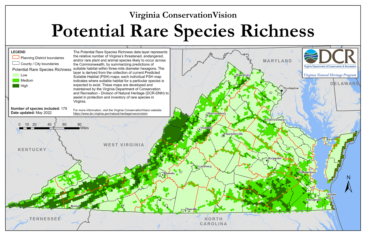
The Potential Rare Species Richness data layer represents the relative number of Virginia's threatened, endangered, and/or rare plant and animal species likely to occur across the Commonwealth, by summarizing predictions of suitable habitat within three-mile diameter hexagons. The layer is derived from the collection of current Predicted Suitable Habitat (PSH) maps; each individual PSH map indicates where suitable habitat for a particular species is expected to exist. These maps are developed and maintained by the Virginia Department of Conservation and Recreation - Division of Natural Heritage (DCR-DNH) to assist in protection and inventory of rare species in Virginia. The Potential Rare Species Richness layer is one of several in a suite of conservation planning and prioritization models developed by DCR-DNH and partners, known collectively as Virginia ConservationVision.

Details

Through the Species Habitat Modeling project, DCR-DNH develops and maintains Predicted Suitable Habitat (PSH) maps for threatened, endangered, and/or rare plant and animal species. These maps are developed using information from known species locations, predictor variables representing environmental conditions, a machine-learning modeling algorithm, and input from species experts. All PSH maps use a standard 30-meter (raster grid) resolution, and are updated as new data become available and/or modeling techniques are refined.

Current PSH maps are included in multi-species summary products, which are used by DCR-DNH and its partners in environmental review and conservation planning. Summary products are updated quarterly. The Potential Rare Species Richness layer summarizes PSH across a tessellation of three-mile diameter hexagons, so as not to disclose sensitive species location information. It is the only publicly available summary layer for PSH maps. Higher-resolution summary products and individual species' PSH maps are available by subscription.

Online Mapping

The Potential Rare Species Richness layer is available for online viewing on the Virginia Natural Heritage Data Explorer.

Data Download

Click here to register and download the data (shapefile format). High-resolution maps are available in PDF and PNG format.

More Information

For more information about the Potential Rare Species Richness layer and the Species Habitat modeling project, please contact Shiva.Torabian@dcr.virginia.gov, phone: 804-225-2820.

Virginia Department of Conservation and Recreation
600 East Main Street, 24th floor | Richmond, VA 23219-2094 | 804-786-6124
Please send website comments to web@dcr.virginia.gov
Address general inquiries to pcmo@dcr.virginia.gov
Copyright © 2025, All Rights Reserved
Last Modified: Wednesday, 28 May 2025, 02:39:21 PM
eVA Transparency Reports View the Virginia Department of Conservation and Recreation's expenditures.
Contact Us | Media Center | Privacy Policy | ADA Notice | FOIA | Jobs | Code of Ethics (PDF)
DCR Organizational Chart (PDF) | Strategic Plan (PDF) | Executive Progress Report (PDF) | Public Safety & Law Enforcement