Department of Conservation and Recreation Department of Conservation and Recreation
Conserve. Protect. Enjoy.
DCR Logo
Mobile Menu
Search DCR Site
Facebook Twitter YouTube Instagram LinkedIn
About DCR
 
State Parks
 
Natural
Heritage
Soil and Water
Conservation
Recreation
Planning
Dam Safety and
Floodplains
Land
Conservation
  • Natural Heritage
  • About Natural Heritage
    • Overview, Mission
    • Natural Heritage Inventory
    • Community Ecology Program
    • Healthy Waters Program
    • Information Management
    • Environmental Review
    • Natural Area Protection
    • Stewardship
    • Staff
    • Internships
  • Natural Area Preserves
    • Public Access Guide (PDF)
    • Special Events and Hunting
    • Natural Area Research
  • Rare Species and Natural Communities
    • Rare Species and Natural Community Search
    • Rare Species and Natural Community Lists
    • Natural Communities of Virginia
    • Locality Summary Maps
    • Rare Butterfly and Dragonfly Atlas
  • Information Services
    • Info Services Order Form
    • Locality Assistance Program
    • NH Data Explorer
    • Species and Community Search
    • ConservationVision and Green Infrastructure
    • Telecommunication Towers (PDF)
    • Conservation Lands Database
    • Wetlands Catalog
    • Species Habitat Modeling
  • Pollinator Smart Solar Site Portal
    • Comprehensive Manual (PDF)
    • Scorecard Templates
    • Virginia Native Plant Finder
  • Native Plants
    • Benefits
    • Natives vs. Aliens
    • Buying and Growing
    • Virginia's Physiographic Provinces
    • Native Plant Finder
    • Flora of Virginia
    • Policy 151 - Plantings on Department Lands
  • Invasive Plants
    • Invasive Plant List
    • What You Can Do
    • Factsheets
    • Invasive Species Working Group
  • Invertebrates
    • Monarch butterflies
  • Caves/Karst
    • Cave Board
    • Cave and Karst Trail
  • Publications
    • Flora of Virginia
    • Peer Reviewed Papers
    • Enews
    • Brochures and Factsheets
    • NH Plan
Home » Natural Heritage » Virginia ConservationVision Recreation Access Model 2019
ConservationVision | Agriculture | Cultural Resources | Development Vulnerability | Forest Conservation | Natural Landscapes | Potential Rare Species Richness | Recreation Access | Watersheds

Recreation Access Model (2019 version)

Model last updated 3/2019.

News

A new model version has been completed. For now, both the "Recreation Access Model" from 2019 and the new "Nature-based Recreation Access Model" are available. This is because there is still a grant round open for the Virginia Recreational Trails Program (RTP) that relies on the 2019 model for scoring. After the end of June 2021, the older model will be fully retired.

You can find the 2021 model here. Current VLCF grant applicants should use the 2021 version.

For information on the 2019 model, continue reading below. Current RTP grant applicants should use the 2019 model.  Current VLCF grant applicants should  NOT  use the 2019 model.

Abstract

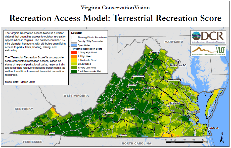
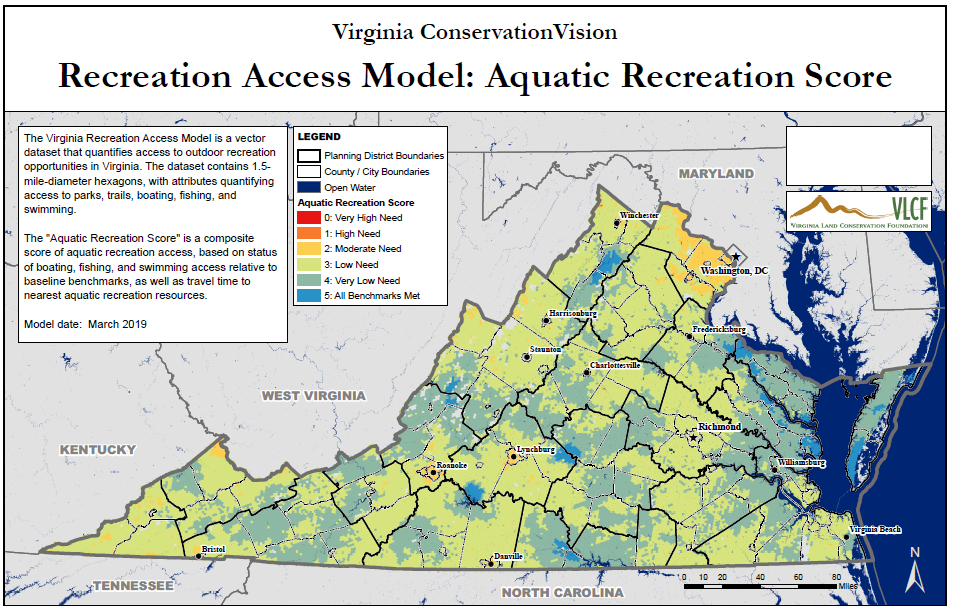
The Virginia Recreation Access Model is a vector dataset that quantifies access to outdoor recreation opportunities in Virginia. The dataset contains 1.5-mile-diameter hexagons, with attributes quantifying access to parks, trails, boating, fishing, and swimming. The term "park" is used loosely to refer to any contiguous block of land with public access for recreation. "Swimming" refers to non-pool, beach or bank swimming opportunities.

This model is intended to assist land planners and granting organizations in prioritizing lands for conservation and recreation access. It helps identify where additional recreation opportunities are needed to achieve certain baseline benchmarks. The benchmarks are as follows:

  • Regional Parks: 10 acres per 1000 people
  • Local Parks: 3 acres per 1000 people
  • Regional Trails: 3 miles per 7500 people
  • Local Trails: 1 mile per 7500 people
  • Boating: 1 boat launch per 10,000 people
  • Fishing: 1 fishing access point per 10,000 people
  • Swimming: 1 swimming access point per 10,000 people

Layers based on the "Baseline Benchmark Status" attribute for each recreation type indicate how many additional park acres, trail miles, or boating/fishing/swimming access points are needed to achieve baseline benchmarks. For all except Local Parks and Local Trails, benchmark status is categorized based on how much would be needed to serve 1000 identical hexagons, rather than a single hexagon, because otherwise the values would be extremely small and relatively meaningless at the regional scale.

Layers based on travel time attributes provide additional measures of access to each recreation type.

Two summary scores are included:

  • The "Terrestrial Recreation Score" is a composite score of terrestrial recreation access, based on status of regional parks, local parks, regional trails, and local trails relative to baseline benchmarks, as well as travel time to nearest terrestrial recreation resources.
  • The "Aquatic Recreation Score" is a composite score of aquatic recreation access, based on status of boating, fishing, and swimming access relative to baseline benchmarks, as well as travel time to nearest aquatic recreation resources.

The full list of attributes included in the model dataset can be found here.

Details

A slideshow overview is available here.

Online Mapping

The model is available for interactive viewing at ArcGIS Online and on the Natural Heritage Data Explorer.

Data Download

Spatial data with metadata, accompanied by a symbolized map document, are bundled in an ArcGIS map package file (MPK file) which is available for download here. You will be required to register in our system to obtain this file. Once you have downloaded and unzipped the file, use the "Extract Package" tool in ArcGIS to extract the MPK file to the folder of your choice. If this file format will not work for you, please contact us and we can provide an alternative.

Additional Resources

The Virginia Recreation Access Model is fundamentally a regional/statewide model, although it does incorporate a local component for parks and trails. For more detailed, city-level analysis related to parks access, you may be interested in the "ParkScore" analysis provided by the Trust for Public Land. ParkScores are available for several cities in Virginia:

  • Arlington
  • Virginia Beach
  • Norfolk
  • Chesapeake
Analyses for other cities may be found by using the search box at the bottom of any of the above pages.

The Trust for Public Land also provides the ParkServe online mapping service to help park planners determine the best locations for adding new local parks. The goal is to strategically place parks to ensure that all city dwellers can walk to a public greenspace within 10 minutes.

More Information

An update of the model is currently in progress!

For more information please contact Kirsten Hazler (Kirsten.Hazler@dcr.virginia.gov, phone: 804-371-6203) or David Bucklin (David.Bucklin@dcr.virginia.gov, phone: 804-225-2820.

Page last updated 3/2019.

Virginia Department of Conservation and Recreation
600 East Main Street, 24th floor | Richmond, VA 23219-2094 | 804-786-6124
Please send website comments to web@dcr.virginia.gov
Address general inquiries to pcmo@dcr.virginia.gov
Copyright © 2025, All Rights Reserved
Last Modified: Wednesday, 28 May 2025, 02:39:20 PM
eVA Transparency Reports View the Virginia Department of Conservation and Recreation's expenditures.
Contact Us | Media Center | Privacy Policy | ADA Notice | FOIA | Jobs | Code of Ethics (PDF)
DCR Organizational Chart (PDF) | Strategic Plan (PDF) | Executive Progress Report (PDF) | Public Safety & Law Enforcement